District Profile : Nandyal
General Information about Nandyal District
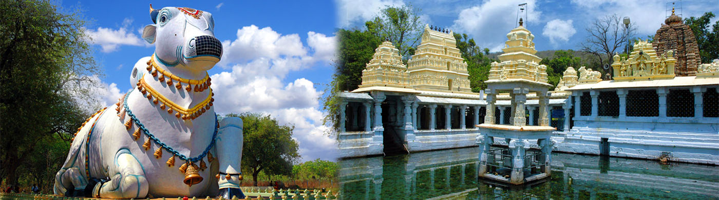
The name Nandyal is from the word “Nandi Alayam”. This place is approximately center point of nine Nandi temples, and it has been an important pilgrimage site since the days of the Vijayanagar Kingdom owing to its nine Nandi temples. It was formed on 4 April 2022 to become one of the resultant 26 districts and one of the district in rayalaseema region. Nandyal district lies between the northern latitudes of 15° 27’ 49’’ and eastern longitudes of 78° 28’ 43’’ .The altitude of the district varies from 100 ft. above the mean sea level.
This district is bounded on the north by Krishna River and Mahabubnagar district of Telengana State, on the south Kadapa and Anantapur Districts, on the west by Kurnool district, and on the east by Prakasam District.
As per 2011 Population census the district population is 1687541, with an area of 9154 Sq. Kms. The Nandyal District comprises of 3 Revenue Divisions. There are 10 mandals in Atmakur division, 13 mandals in Nandyal and 6 mandals in Dhone division with a total of 29 Mandals. One Mandal i.e. Srisailam is a Non Agriculture mandal consisting of Hills, Hillocks and Forests. January, February and March months are usually pleasant with moderate winds from South-East. April and May are hottest months of the year, when the wind shifts to Southwest with increased force and brings welcome showers by the end of May. During the succeeding four months i.e. southwest monsoon the wind blows from Western side in Major parts of the district and brings fair quantum of rainfall. By the end of September the wind is light and pleasant forecasting the onset of North East monsoon. In November and December the weather is fine, Rainfall is rare and wind is light with occurrence of heavy dew. District normal rainfall is 724.9 mm/annum. During 2019-20 the rainfall received is 784.1 mm.
- The total geographical area of the district: 9.154 lakh Ha.
- Forest area covered during the 2019-20 is: 3.017 lakh Ha. Which is 32.95% of the total geographical area.
- The net area sown is 3.37 lakh Ha, which is 36.81% of the total geographical area.
- The total cropped area in the district 3.823 lakh Ha. The area sown more than once during the year is 0.45 lakh Ha.
- The total area under horticulture is 0.39 lakh Ha. with mango, citrus, banana are major fruit crops, and onion, dry chilli are major spices crops, apart from vegetables and flower crops.
- The cropped area under all sources of irrigation, like canals, tanks, wells and other sources during 2019-20 is 1.88 lakh Ha.
The principal rivers flowing in the district are the Krishna and the Kundu. The Kundu also called Kumudvathi rises on the western side of Erramalas winds its way into Kunderu valley and flows in a Southern direction collecting drainage all along its course from either side. It flows through, Midthur, Gadivemula, Nandyal, Gospadu, Koilakuntla, Dornipadu and Chagalamarri mandals and then enters Kadapa District. Srisailam Right Bank Canal (SRBC) Irrigates 1.90 lakh acres of Nandyal, Banaganapalli, Koilkuntla mandals of the District. 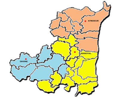
K-C canal irrigates 1.20 lakh acres of Nandikotkur, Pagidyal, Jupadu bunglow, Pamulapadu, Velugodu, Gadivemula, Bandi Atmakur, Mahanandi, Nandyal, Gospadu, Sirivella, Rudravaram, Allagadda, Chagalamarri, Dornipadu, Uyyalawada, Koilakuntla mandals. Velugodu, alaganur, owk reservoirs, and telugu ganga project providing drinking and irrigation water to the different parts of the district.